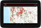
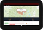

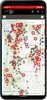

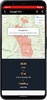
The FWAC Wildfire Map provides users with comprehensive tracking of wildfires across the nation. This invaluable resource offers detailed information on active fires, regardless of size, including substantial incidents, prescribed burns, and minor fires that may not typically make the headlines. An additional key feature is the ability to utilize your device's location services to identify and inform you of wildfires in your immediate vicinity. This Android application is designed to keep you informed about potential fire-related dangers and is an essential utility for those who need real-time updates on wildfire activity. The app ensures users can stay ahead of the curve when it comes to fire safety and awareness.
Through this platform, individuals can access a range of features that are not limited to just maps and alerts. The system also provides educational materials about fire prevention and what to do in the case of a nearby fire emergency. By delivering this information in an easily accessible manner, it becomes a tool for empowerment, letting users take proactive steps to protect themselves, their families, and their properties.
For those who have a keen interest in the broader environmental implications of wildfires, FWAC Wildfire Map includes analytical tools that lay out the fires' impact on the area. This can be critical for researchers, environmentalists, and policy-makers who are involved in managing fire-prone environments and for the general public eager to understand the scale and consequences of these natural events. The application ensures that the most current data is easily available, reinforcing the safety of communities potentially affected by these disasters.
Requirements (Latest version)
- Android 8.0 or higher required

Comments
There are no opinions about FWAC Wildfire Map yet. Be the first! Comment